
Forum Replies Created
-
AuthorReplies
-
Yekaterina Yushmanova
Just came back from there. You can camp on Spring Is at the West Coast Expedition’s site (on the north side of the island), they won’t be using it until June. There is a sign at the site asking for a donation if you are staying there. I recommend taking the water taxi out as the inlet is a bit of slog and if winds blow up it will be too much for a beginner. If you get calm weather, the Mission group is lovely.
No wildlife warnings at Rugged as of Saturday. We stayed at the South beach and hiked to the North one – very easy short hike. While protected from the SE, the north beach is very exposed to northerlies and was actually quite rough when we went there. I wouldn’t recommend crossing the Kyuquot channel with a beginner to get there.
The estuary around Fair Harbour is pretty and sheltered but is a very short paddle.
Feel free to text or call if you want any more details)
604.600.3738 Katya
Yekaterina YushmanovaI have an Anker power bank for all USB compatible devices and it is awesome for that. Doesn’t work with the the radios though, so looking forward to see what others are using fo that purpose.
Yekaterina YushmanovaYou would enter the first option as:
050° 01.560 – 124° 49.535 (add a zero in front where needed)
or second
050° 01.56 -124° 49.54 (round up the seconds, less precise)
Correct?
Mick AllenTwo similar answers:
1) too much safety is when the ‘safety’ eliminates too much of the challenge/risk. We need challenge to grow.
2) too much safety is when the ‘safety’ has minimal failure event impact. Some good examples of this are: a) pfd for everyone – huge impact on failure events, so great. b) heaving line for everyone – minimal impact on failure events, so too much.
Martin Feuchtwanger@Nick: I, too, have the HX870. Kevin’s list of location formats is correct
ddd°mm.mmm
ddd°mm.mm
ddd°mm’ss”There is no decimal degrees option.
Nick HeathFirst: thank for asking an easy question, Kevin. Often our Forum questions are imponderable! However, I hope you meant the first option was ddd.ddddd as Martin assumed, not as you wrote i.e. “ddd°mm.mmm”,
Second: thanks for a succinct, accurate answer, Martin. Right on!
Third: Increasingly, I find degrees and decimal degrees is the preferred format in use – it is the standard in aviation. It reduces the confusion over what units are in use (in radio communications especially and avoids dividing/multiplying by 60. The bad part is that it is harder to use with a nautical chart, because it doesn’t give the minutes which are clearly given on charts, so it is harder to quickly locate the correct point from a given coordinate.
Most sailors, mariners and I prefer ddd mm.mmm – degrees are separated from minutes but we don’t bother with seconds – we just use a decimal of a minute. This is a practical hybrid format that works well with marine charts.
The last option uses seconds instead of decimal minutes and I think this is too confusing for people although it is time-honoured and traditional. I find I make more mistakes over units when using this format. However, the Govt of Canada sticks doggedly to this older format for issuing notices etc so you need to know what it is and how to convert.
The great part about these machines (GPS, plotters etc) is that they don’t really care and can instantly convert from one to another format, so I often re-set my GPS to another of these formats to capture a new waypoint given to me in a format that I don’t currently use – then I switch the machine back and everything is converted into my preferred format, whatever that might be.
Sorry – my explanation was far from succinct!
Chris DennisKevin, try the converter attached. https://www.fcc.gov/media/radio/dms-decimal
It’s a bit clunky to do serveal of these but, with patience, it gets the job done.
Martin FeuchtwangerThe first map coords format is ddd.ddddd (i.e., decimal degrees) which is not an option on your radio.
The second format is ddd°mm.mmm (i.e., degrees and decimal minutes) which is the first option on your radio. (It is also the second radio option but with lower precision.)
FYI, the third radio format is degrees, minutes and seconds.
Kevin AmosI have a Standard Horizon HX870 VHF radio which allows me to enter a manual waypoint. BC Marine Trails Map gives me coordinates for campsites that I would like to enter into my VHF. The map gives me coordinates in two formats such as this.
Coordinateslat 50.02600 lng -124.82559
Coordinateslat 50° 1.560′ lng -124° 49.535′However my VHF has the following format options
“ddd°mm.mmm”,
“ddd°mm.mm”,
“ddd°mm’ss””How do I manually enter a coordinate into my VHF?
Cameron RedenbachCan we get a item by item break down ?
thanks
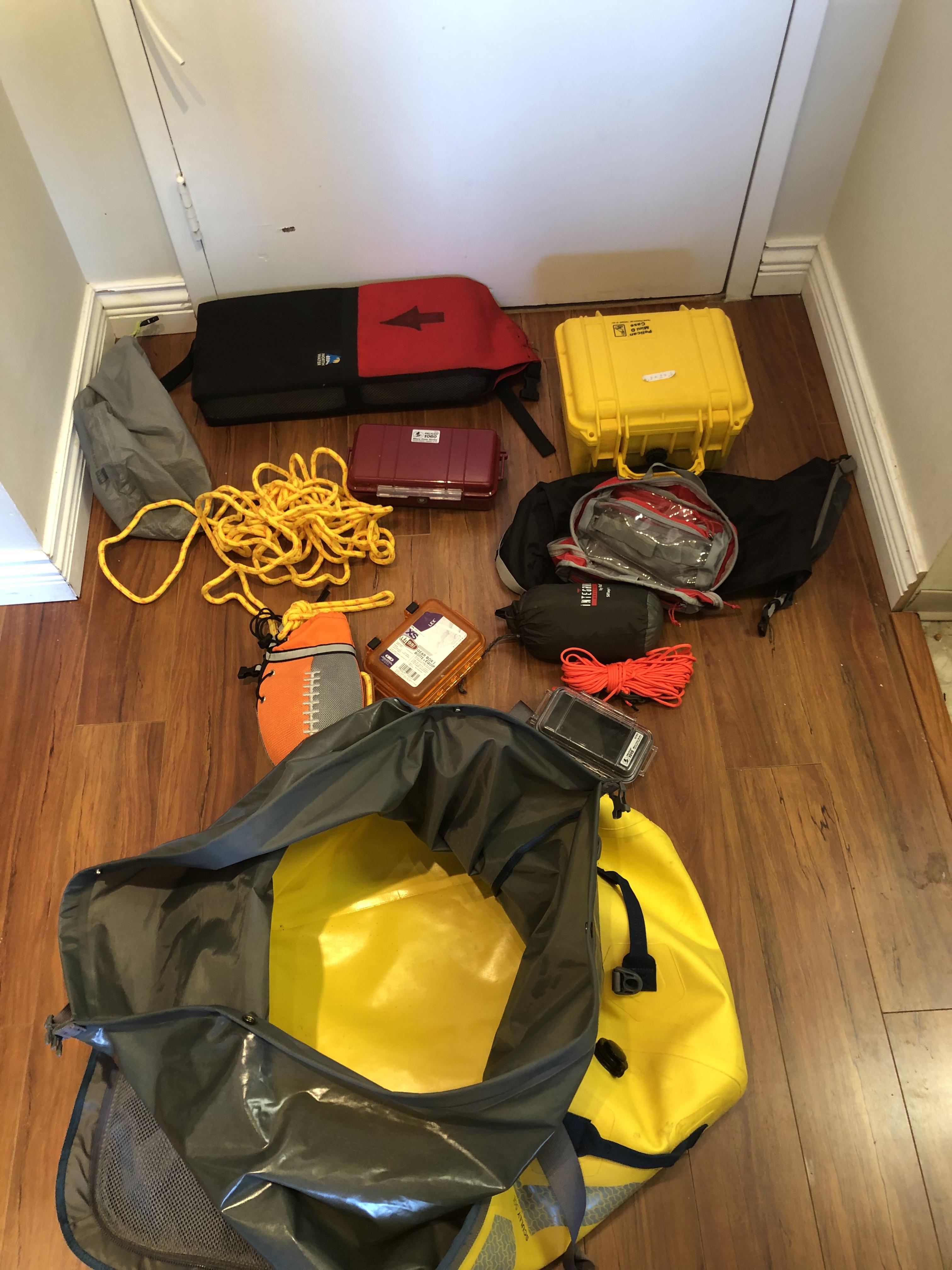
Daniel Del Vecchiodry bags,/box, siltarp, throw bag, self Rescue float and first aid bag. Sold as a kit 200$
 Daniel Del Vecchio
https://westerncanoekayak.com/lithium-battery-15ah-water-resistant/
https://www.voltaicsystems.com/9-watt-kit
I don’t have “field experience” yet but been researching the subject a lot. I’m an amateur radio portable power is very important for us. So here a few things i found that may be of interest. At the end it depends how much power and what kind of power. Many panel have a usb ports but for example in my situation all my radio stuff use 12v so i can’t use it. My set up i will be trying this season is an anker that does also 9v and 12v. My panel will be a 5 w powerfilm in a chart bag when i paddle and adding a 10w when i get to shore. I can go on and on that topic but a good presentation on solar is :
Cynthia MateriSign up for the Beginners course on June 8 and 9. Learn to understand your kayak, it’s parts and how it floats. Learn ways to get into it, how to get it to move the direction you want, and how to go long distances without getting tired. There is lots on safety and practice on how to get back into your kayak should you fall out. Also introduces what you need to plan a trip such as charts, tide and weather information. This course will give you the basic skills and knowledge to go on trips in sheltered waters or to join competently led trips in places such as Indian Arm and the Gulf Islands. Sign up under ‘Training/Course Schedule’ on the main web site page.
May 21, 2019 at 7:47 am in reply to: Short Notice Paddles. Personal trips not officially sponsored by SKABC #17204Maureen BenzonThe weather looks to be warm and sunny so we will be off the water at noon. Sign up through the trips page.
Joe BarnwellI see there is a posting from July 17 about recommendations for solar power for charging electronics on trips. There were a couple of responses.
I’m wondering if anyone has any other suggestions for solar or portable power packs to charge devices such as camera, iphone, GPS, marine radio or satellite phone? For kayaking.
Thanks, Joe
please reply by text to 604-649-1126
-
AuthorReplies