Forum Replies Created
-
AuthorReplies
-
Former Member
Thanks for the resources Daniel!
Former MemberThanks for your generous offer of some phone coaching Ellen. We may take you up on that. I think I’ll start by going and buying some chart(s?) for Indian Arm and dig into those for a bit. Then when I have my list of questions, I’ll probably reach out via e-mail. Thanks! Phil
Former MemberThanks Yekaterina! We were thinking of starting off as you suggest, with familiar territory such as Indian Arm and maybe Pitt Lake. Thanks for the suggestion.
Former MemberThanks Nick! I was wondering about buying and printing electronic charts, laminating them, etc. What nav application do you use on your computer?
Former MemberHi Marina,
I have a paddle float, a heaving line, and a pump. I am traveling in Europe right now and won’t be back until July 23 if you can wait until the . I’ll be in touch then.
Former MemberI’m a professional mariner – I navigate big ships for a living, but my real passion is kayaking! I’m always happy to help my fellow kayakers whenever I can because many have helped me. Several years ago, a friend and I also circumnavigated Vancouver Island using only a Chart and compass for navigation – no electronics whatsoever so I’m a big believer in the “old school” methods.
Most local marine stores carry charts as do some kayaking stores. Your best bet would be to go there and pick up a chart catalogue, which is free. The chart catalogue is basically a chart covering the area (in our case, it covers the whole west coast). You can then pick an area you where you’d like to go and it will show you the chart number(s) you will need. They’re colour coded for larger and smaller scales – one red one blue, but I can’t recall which is which. Pick the largest scale ones you can for the area – i.e. the ones that have the most detail but cover the smallest area. You especially need these ones for kayaking because the details are more important for kayakers than anyone else. Please stick with only charts from the Canadian Hydrographic Service (or foreign equivalents), where ever you decide to buy them.
Anyways, I’d be quite happy to discuss these things more if you have questions. You can contact me at ellen.w@me.com. I’m working right now – the hours are long and rest is critical. I’m home in about 10 days and can talk further then, but for now I can answer quick questions by email.
Yekaterina YushmanovaWelcome to the club, Carlos. Please contact Chantal or George to check if your level of experience is sufficient for the course. I believe the course is full at the moment and you will need to be on the wait list.
You can rent a boat and safety gear from MEC or other rental shops but need to be able to transport it. You don’t necessarily need a rack some foam can be sufficient. You can also see if anyone else in the class is renting and try to carpool with them.
Good luck!
Former MemberI am new to this too but here some of the ressources I used or learn from:
http://www.charts.gc.ca/publications/chart1-carte1/index-eng.asp
http://geoportal.gc.ca/eng/Gallery/MapProfile/9
also SKABC have a library with some books on the subject.
Yekaterina YushmanovaWelcome to be club! Nick and Tracey did a great overview of the options out there. My two cents to add: I found it very useful when learning the basics to get a chart of a local area where I paddle often (False Creek, Deep Cove, etc). I would chart a course even for a half day paddle at home, locate a spot or two of interest, and then practice following the course on the water and locating the spots. Made me faster and more confident.
I usually buy the charts from the stores Tracey mentioned, but Nick is right that laminated once are easier to use and last better.
Nick HeathYes, welcome, Phil.
I’m not recommending what I do, but I’ll tell you anyhow…
Yes, I have many paper CHS charts, some old some newer. I love them and, for the information that they contain, they are inexpensive, but they are inconvenient. To start, they are not a good fit in a chart case that is usable in a kayak. Secondly, they need lots of home storage space, preferably flat. Thirdly, one never seems to have the correct chart when wanting to view one on a cold winter night at home…
So electronic charts are far more convenient because one can view which ones you want, print out (and laminate) those that you will need on a trip and save some money, too. A printed laminated chart is (I think ) the best for kayaking, although the purist navigator will complain that the necessary pencil notations cannot then be made as you check your running fixes and do dead reckoning (deduced reckoning, really) as you paddle along.
I have 2 sets of CHS electronic charts – one a bit old (8 yr) and one ancient. I regularly use the ancient ones because they have no security key and after changing computers numerous times I eventually lost the security code to the newer ones.
Technically, the master of a vessel must carry current charts and that means updating them annually or whenever a ‘Notice to Mariners’ is issued for that area. This is definitely overkill for kayakers, who don’t need to know that Q53 buoy has been moved 15 m to the W or that the revised charted depth in Friendly Channel is actually 7.8 m rather than the originally published 8.5 m. The terrain does not move much.
I will be happy to share some or all of these old charts with you. To read them you will need a navigation application on your computer. There are some good ones that are free or some inexpensive ones you can buy. You can usually save output as a pdf and use a colour printer at some retail outlet if you don’t own one.
Another way to go is to use Navionics – always current (as required), available for your handheld devices, but not to easy (for me at least) to print off to take with you.
I would never rely on electronic gizmos for 100% of nav needs.
At one time I bought Garmin’s BlueCharts for my GPS and that worked well for a while, until the device ate them – an expensive loss!
I prefer route planning on a computer and CHS electronic charts do that well.
I’m sure there will be others with very differing opinions!
Former MemberHi, new in SKABC.
i would like to take the Rescues and Boat Handling Course (previously Strokes & Rescues) training course. I have some little experience kayaking in Bowen, Gambier, False creek (6 times total)
Do I need to take the beginners course before in order to take the rescue and handling course? Or I’m ok? Where can I rent kayak and equipment nearby (as I don’t have a rack on my car. Thanks
July 7, 2019 at 6:18 pm in reply to: Charity trying to buy undeveloped land in Princess Louisa Inlet for $3M #17370Mick Allen[if you right click on the image and choose ‘view image’ – it’ll show at a much larger scale, so the coastline is more easily seen.]
July 7, 2019 at 6:11 pm in reply to: Charity trying to buy undeveloped land in Princess Louisa Inlet for $3M #17369Mick Allen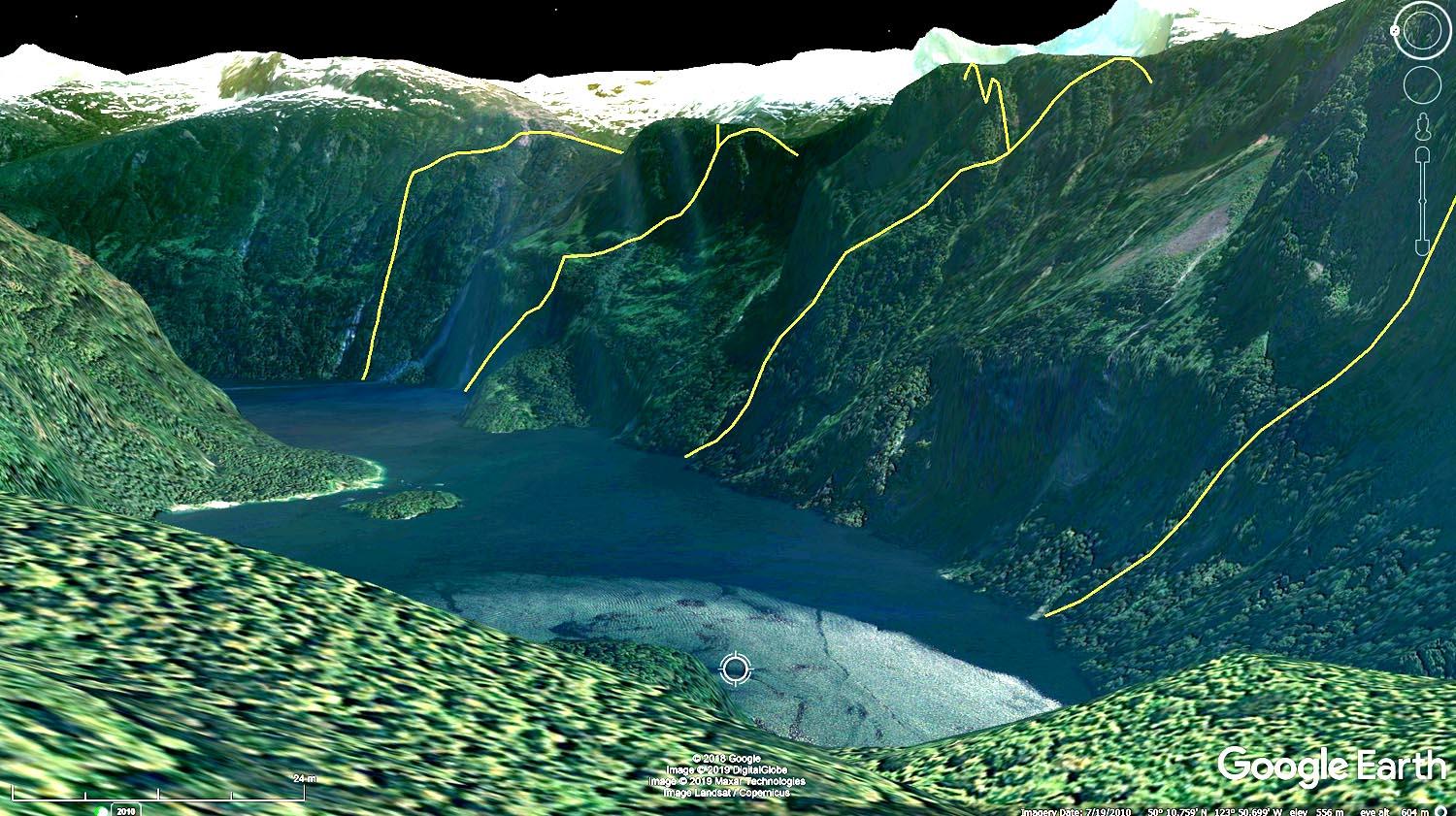
These are the boundaries: for kayakers not so great: far away, mostly in shadow, steep terrain, no apparent usable access, no apparent beaches or campsites – and it’s a huge amt of money.
Former MemberThanks Tracey! That’s very helpful!
Former MemberWelcome to the club Phil and Peggi. It’s a great idea to use charts for navigation even if you have a GPS, it is not “old school” at all. If you are in Vancouver, you can buy charts and tide tables at Ecomarine on Granville Island, or Steveston Marine on W 5th or Richmond. The club also runs a Navigation course every year usually earlier in the season that talks about navigating, so you can look out for it next year in April/May.
Happy paddling!
-
AuthorReplies