Joan Boxall: SKABC member, blogger, poet, and travel writer, had some fun on
a (horse)-racy Thormanby Islands trip.
Read all about it on her blog,
http://www.joanboxall.com/horsing-around-thormanby-island-british-columbia/

Joan Boxall: SKABC member, blogger, poet, and travel writer, had some fun on
a (horse)-racy Thormanby Islands trip.
Read all about it on her blog,
http://www.joanboxall.com/horsing-around-thormanby-island-british-columbia/
The trip started off very badly for me. I had just bought a new Greenland paddle, a high-tech blade made out of armalide. Armalide is a semi-mythical material, like mithril, supposedly indestructible by anything short of dragon fire. It worked very well for kayaking across the channel from Bamfield to Diana Island in the Deer Group, but once at the campsite I tried a simple Greenland roll and the paddle split in half while I was underwater. This was extraordinarily disconcerting, like the feeling Saruman must have had when his wizard's staff was shattered in "The Treason of Isengard". Fortunately I had a back up.
The day before, we had driven from Port Alberni to Bamfield, eighty kilometers of logging road enlivened at its mid-point by a poem, written in marker pen on a cardboard poster nailed to a pinetree, celebrating the solstice. Bamfield’s 200 inhabitants spend the winter months creating whimsical decorations for its boardwalk, including a grove of painted wooden mushrooms.
After the hot drive down the logging road, we assembled in the motel’s restaurant in search of cold beer. Our spirits rose at the sight of a row of beer pull handles at the bar, and were then dashed by the news that, although a wide variety of local craft beers would be available in a few months, the only thing available at the moment was a large ice chest of characterless American lagers.
Apart from the incident with the armalide paddle, the trip from Bamfield to Diana Island on the first day was uneventful. It was sunny, with a light wind and about a foot of swell. We pitched camp on the North shore of the island. It occurred to me that the campsite had a number of natural advantages, such as a rock-free passage to the beach, and the shining whiteness of the beach itself. Later on other members of the group explained to me that neither of these features was natural – the First Nations inhabitants of the site had cleared the rocks, and the whiteness of the beach was the result of millennia of their eating shellfish and discarding the shells.
There was heavy rain on the first night. Fortunately we had a large, professionally-tarped kitchen area. The following morning it was clear and clam, so we set off towards Folger Island, a small rocky island west of Edward King Island. The wind gradually increased as we approached Folger, the swell building up to four or five feet, so we abandoned our original plan of circumnavigating it and instead retreated to the west side of Edward King for lunch. From here, we passed between Diana and Edward King to the east side of the latter, and followed its coast down past an impressive series of sea caves, including a three-way sea arch.
While we were on this coast we could hear a deep, melancholy howl. At first we thought this was a foghorn, but later realized that it was a wave-actuated buoy in the Trevor Channel.
The party then split up, some of us returning to the campsite, a second group continuing to the southwest tip of Edward King and bagging the rocky islet at the end.
As we returned to the campsite, we could see fog forming between us and the Broken Group. Later, as we were preparing for supper, a deer walked down the beach and briefly stood on its hind legs to eat the leaves of an overhanging tree.
Wednesday morning started off foggy, so we didn’t get onto the water till 10:00 am. This time we headed north-east, up the coast of Fleming Island. A two-foot swell was rolling gently up Imperial Eagle Channel, surging through a series of rock passages and sea caves. The last and most impressive sea arch was at the western entrance to Robber’s Passage, at the north-east end of Fleming. Members of the party successively rode the swell through the arch, some of these rides being noticeably more exciting than others.
Robber’s Passage was strikingly populous in comparison with the more south-westerly islands, with a white-framed yacht club and a collection of yachts. A fresh wind was blowing from the far side of the passage, and when we crossed through into Trevor Channel, we met a two-foot chop.
The group again split, three kayakers setting a direct course for the campsite, the remainder of the group following the south-east coast of Fleming. As one of the three direct-route kayakers, I was very surprised to find the coast-following kayakers arriving at the campsite just fifteen minutes behind me. The three of us on the direct route had been paddling briskly, following a constant bearing, whereas the coast-followers had, we supposed, been frolicking in rock gardens and poking into the crannies of the coastline, so we had not expected them to come into sight for another hour or more. We eventually concluded that our route, though direct, had also been head-on into the waves and the wind, both of which the coast-following party had avoided.
On Thursday morning some of the group made an early start and paddled back to Folger Island. Again, as we approached it the swell grew higher. As we began to circumnavigate the island, we found the entrance to a sea cave on the northern side. It went very deep into the rock, and the roof came down almost to the water, but at intervals it was just possible to glimpse a bright light at the far end.
Going in search of the far end of the cave, we came to a beach covered with rocks. From somewhere behind these rocks came a low gurgling sound and an occasional squirt of spray. There was no way of approaching this by kayak, but exploration on foot led to a doorway in the rock, with water spilling over the doorstep. Looking through the doorway, it was again possible to glimpse flashes of light, periodically cut off by the waves. Anyone wishing to traverse this cave would have to portage their kayak up to the doorway, then swim it through the passage until the roof was high enough to board – technically possible, but perhaps not worth the effort.
We now paddled on to the west side of Folger, where the swell bounced back from cliffs to create an area of choppy, confused waves, or clapotis. A bald eagle perched on top of the cliffs and watched us. The water grew noticeably calmer as we moved away from the island and crossed over to Edward King, then up its eastern shore.
Thursday night was wet and windy, but the rain had stopped by Friday morning, and the sea in front of the campsite was calm. We again split into two groups, the smaller group making an early start and heading back towards Edward King Island. The wind was noticeably higher than the previous day, and by the time we reached the distal end of Edward King, we were in a four-foot swell with noticeable wind waves on top. A fishing boat a little further out was tossing about in a lively fashion. We went partway out towards it, then retreated to the more sheltered coast of the island, where we found a baby seal swimming close by its mother.
On several occasions this day, we remarked on the great contrast between the calm water in sheltered areas and the rough seas to be found where the wind blew, just a few hundred meters away.
After getting back to camp, at least one member of the party saw something that was almost definitely a whale, quite likely a humpback, about two hundred meters away.
Saturday morning we struck camp with remarkable efficiency, and were on the water, as planned, by 9 am.
Thanks to Karin for organizing!
 Seven people signed up for the trip but three people cancelled two days before the trip. The remaining participants, Maureen Benzon, Heather Kirk and Earl Elliott and myself met at at Porteau Cove provincial park which was surprisingly busy at 8:15 on a Sunday morning. We were on the water at 9 am as planned and paddled in the calm turquoise water towards the sea mist shrouded Defense Islands with Mount Wrottesley and Potlatch Mountain soaring above on the peninsular.
The final wisps of fog disappeared as we followed the shoreline to Potlach Creek and 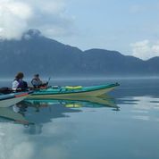 beyond to the rocky headland opposite Latona Point on Gambier Island. In perfect conditions the paddling was pleasant and relaxing: one of those occasions when one can easily retreat into a Zen like trance induced by the steady rhythm of the paddle and the quiet, peaceful environment. We reached the meadow at Douglas Bay, Gambier Island at around 11: 30. We had this pleasant spot to ourselves while we ate lunch in the warmth of the sun and enjoyed the view across Ramilles Channel to the western aspect of Anvil Island and the mountains beyond ranged above the Sea to Sky highway.
We were in no hurry to leave and somewhat reluctantly pushed off the beach at around 12:30 pm when very predictably the inflow wind hit us in the face. This gave Maureen an excuse to produce her latest kayaking gizmo, a pocket anemometer. Maureen asked us each to estimate the wind speed and Heather won handily by estimating a 10 knot wind which was very close to the instrument reading of 9.7 knots. Interestingly the other estimates were all on the low side; but then Earl and I are inveterate optimists about kayaking conditions. We followed the shoreline of Gambier Island almost to Brigade Bay before heading across to Pam Rocks which, as usual was populated by dozens of Harbour seals basking on the rocks. We turned down wind and coasted to Christie Islet where we saw the large resident population of Glaucous-winged gulls with some surprisingly late fledglings, but also Harlequin Ducks, Oyster Catchers, Pigeon Guillemots, Ruddy Turnstones and Brandt’s Cormorants. On then to the S.E. point of Anvil Island and then using a slight ferrying course to allow for the wind blowing straight up Montagu Channel we made our way towards Porteau. The wind never appeared to rise above 10 knots so we only had minor surfing on this last leg of our outing but never the less it was a fast paddle and we touched the shore a few minutes after 3 pm. There was a lot of activity at Porteau with folks picnicking, launching and landing boats, scuba diving and generally enjoying a beautiful summers day and all this busyness was a sharp contrast to the spacious almost deserted waters just a short paddle away.
 We covered 16.5 nautical on our wide ranging circumnavigation of Anvil Island and we were on the water for close to 5 hours for an average speed of 3.3 knots.
It was agreed that we had had an excellent day of paddling in great surroundings. For my part I enjoyed immensely the trip with such convivial and capable companions; thank you Heather, Maureen and Earl for coming along.
As something of a post script I should say that this is the third time this summer that I have made similar trips out of Porteau Cove; a reconnaissance day trip prior to the Kayak Cuisine weekend in late May, the KC trip on June 7/8 and the trip described above. I typically make similar trips in the area a couple of times each year; sometimes as early as April and sometimes as late as October. No doubt the fact that I live in Lions Bay just a short distance south of Porteau influences my choice of this destination but I rarely encounter any other paddlers in the area and I am puzzled by this. Central Howe Sound and Porteau Cove may seem a long drive away for many people but the Sea to Sky highway is now excellent and it takes perhaps 30 minutes to drive from Lions Gate bridge to the put in. Admittedly, inflow and outflow winds can be a factor, particularly when crossing Montagu Channel, but close attention to the weather patterns and forecasts will provide plenty of opportunities for wonderful day or weekend paddles in an interesting and scenic setting.
Tony Clayton.
Hi everyone,
The popular kayak landing at Douglas Bay, on the South East side of Gambier Island in the Howe Sound is in jeopardy as the Ministry of Forests is aggressively trying to turn this into a log dump. The Ministry also wants to award two logging licenses encompassing a large area of the island popular with hikers and all visitors to the island.
I have been asked by Perry Sanche, a key advocate against this proposal, to encourage anyone with an interest to please come and join them at these important meetings (details below) with the Ministry of Forests, Lands and Natural Resource Operations (FLNRO). Perry is supported by several groups including the Gambier Island Conservancy, The Islands Trust and the Sea to Sky School.
Hope you can make it.
Thank you,
Linda Rushlow
Marine Trails, Parks and Conservation
SKABC
Meeting information from the Gambier Island Conservancy
Public Information Meeting
Date: 6:30 Thursday evening, July 24th
St. Francis-in-the-Wood Church, 4773 South Piccadilly Road, West Van
(This is near Caulfield Cove and Lighthouse Park.)
Public Drop-In
Date: Friday, July 25, 2014
Time: 9:00 a.m. to Noon
Location: Sewell’s Marina Boardroom
6409 Bay Street
Horseshoe Bay, BC
Some of the most wild, close to Vancouver hiking is on Gambier Island in Howe Sound. The northeast quadrant of the island is pretty much untouched Crown land that thousands of outdoor campers and hundreds of hikers explore each year.
The Ministry of Forests is bound and determined to turn this land into two big woodlots. This means that part of each piece will get logged each year, for many years to come. Very little revenue will come back to the province and significant old-growth forest will be taken, not to come back within many, many lifetimes, if ever!
More information at gambierc . ca
Check our Twitter feed at @GambierConserv
Thanks so much for supporting wilderness on Gambier Island, the Wild Heart of Howe Sound.
Gambier Island Conservancy
Our six-person group – Graham, Geoff, Ted, Cathy, Joan and John – rendezvoused in the Port Alberni Tim Hortons at 11:30 am on the morning of Sunday, May 25. From here we drove in convoy through light rain in the direction of Tofino. Somewhere along this road, we knew, was the turn-off to the launch site at Torquat Bay, but no-one was sure exactly where. Each time we passed an unmarked dirt road forking to the left, we debated briefly whether this might be the Torquat turnoff, then drove on, increasingly worried that we’d already gone past the fork. Then, just as we were about to turn around, we came upon it, clearly and unmistakably signed. Future travellers may find it helpful to note that the turnoff is at 79 km past Port Alberni.
Thirty kilometers along a dirt road took us to the launch site, run by the Toquaht First Nation. The site has changed since 2013 – launching at low tide used to involve a hundred-meter hike across mud and clamshells, but at the new site the water is near, even at low tide.
We set off at about 1600 hours in light drizzle, first crossing the Loudoun Channel to the Stopper Islands, then on to the lighthouse at Lyall Point and southwards, past Hand and Brabant, to the gloomy campsite on the north of Dodd. The site was decorated with a raven carved from a tree-stump, possibly by a twenty-first-century camper with a hatchet rather than a nineteenth-century Tseshaht artisan. As we stood beneath the dripping trees, looking north at the cold grey rain falling into the sea, it occurred to at least one member of the party that five days of this was going to be a long time.
After a rainy night, Monday dawned calm and clear. We struck camp and went clockwise around Dodd Island, through the channel between Dodd and Willis and past the campsite on the north shore of Willis. From here we headed south, just scraping through the shallow channel between Trickett and Turret, then landing at the campsite on Clarke. This was strikingly beautiful – the site was on a peninsula at the north of Clarke, surrounded by white shell beaches and luminous blue water. Behind the campsite was a meadow in which, incongruously, there stood a tall brick fireplace and chimneypiece. After we had been at the site a few hours, a heavily pregnant deer wandered out of the woods and between our tents.
From behind the fireplace, a trail runs into the woods. Someone went to considerable trouble to build the trail – there are flights of wooden steps – but it has not been used or maintained for a long time. The steps are thickly covered with moss, and the trail beyond them is blocked by fallen trees. At one point the trail crosses a plank bridge over a concrete cistern, now disused.
At the far end of this trail there are cliffs and a view of the ocean to the south of the island. In the distance, tall bursts of spray were visible as the ocean swell broke over exposed rocks. At this point one member of the party encountered a mink, a weasel-like creature about 80 cm long with a light-brown coat. It seemed curiously unafraid.
The same mink, or possibly a different mink, visited our campsite early the next morning. An eagle swooped from a nearby tree and grasped the mink in its talons, but the mink turned, nipped the eagle with its teeth and twisted free.
Three of us witnessed a slightly more successful eagle’s attempt to swoop on prey: this particular eagle had swooped on a fish in the middle of the bay, but, having seized it, found it too heavy to lift. Unwilling to let go, it slowly flapped itself along the surface of the water, dragging the fish behind it, and after a long struggle reached a patch of rocks. Several other eagles immediately swooped down to contest possession of the fish.
The camp on Clarke Island was the only point in the trip at which we encountered other kayakers. Two German young men were on a guided tour with a Canadian guide, Jeremy. They told us that their plan was to explore Dempster, Wiebe and Effingham, then to paddle directly back from Clarke to Ucluluet. They also mentioned a geographical feature on Dempster, the “Dempster Squeeze”, a narrow passage from, Jeremy said, one side of the island to the other, suggesting an image of something like the Corinth Canal.
It was at about this point that the marine weather forecast began delivering warnings of 30-knot winds, due to begin in two days time. As the week went on, the due date moved ahead by twenty-four hours for every day that passed, so near-gale-force winds were perpetually in the offing yet never arrived. However, it is probably best not to conclude that “Gale warnings are always exaggerated; you can safely discount their predicted speeds by at least 50%.”
On the basis of these warnings, we decided that it would be prudent to retreat to the campsite on Gibraltar, with access to a lot of well-protected channels between the islands. So on Tuesday morning we again struck camp and set out south-west, with the idea that, since we were going to be forced to retreat to the inside of the island group, we should seize this opportunity to experience the Outside before the wind got too high.
As we went around the Drum Rocks west of Clarke, the swell gradually increased to about two meters. For at least one member of the party, ocean swells this big or bigger are still a new experience, somewhere on the spectrum between “exhilarating” and “panic-inducing”. Just the scale of the swell, areas of ocean the size of a tennis court humping up then dropping back down at stomach-turning speed, inspires awe. Then there’s the breaking of the swell on the rocks and the disturbing glimpses of boomers – innocent-looking patches of sea that only exploded into surf every few minutes, as an exceptionally large swell reached a hidden rock. None of this had really been apparent from a glance at the marine chart – it had looked easy to draw a continuous route west of Clarke and Benson, then heading across the Coaster Channel to Wouwer, but now every path seemed to be blocked by areas of white foaming surf.
Reassuringly, the more experienced members of the party did not seem at all dismayed by this quandary, but found a route through the apparent hazards to the north coast of Batley Island, then the calm inlet between Batley and Wouwer. After an only-marginally-successful search for sea-lions, we paddled across to Gilbert for lunch, where, coincidentally, we met Jeremy and the two young Germans, coming back from Effingham. One of the young men had been obliged to wet-exit while traversing a sea cave, but appeared unscarred.
The wind had increased to about 15 knots as we headed north across Coaster Channel, with some white-caps. We went up to Onion Island, then through the calm interior waters of Jacques to the campsite on Gibraltar. The Gibraltar site is on a peninsula with extensive views to north-east and south-west.
The marine forecast on Wednesday morning warned of winds increasing to 35 knots by late afternoon. We decided that it would be safe to cross the Sechart Channel to the Pinkerton Group, monitoring the wind speed and coming back if it seemed to rising unduly.
The Pinkertons are outside the Broken Group and have a different feel – paddling between them is more like paddling up a forking river that runs through forest and meadowland. Inside the Group the weather was calm, but as we emerged back on the Sechart Channel, the wind had increased to 12 knots. We discussed strategies for crossing, but, just as we had decided on the best approach, the wind died away. We felt vaguely cheated.
We got back to the campsite just as a storm cloud approached. But although we could see rain falling over Torquat Bay, the cloud dissipated before it reached us, and there was brilliant sunshine for the rest of the evening. After the sun had set, there was a very faint phosphorescence in the water.
That night, we heard a wolf howling on the island.
As of Thursday morning, the marine forecast had changed to 35-knot winds on Friday afternoon, with more 30-35 knot winds on Saturday and Sunday. Weighing the options of being stuck on Gibraltar for a few extra days versus paying $70 per capita to be towed out, we decided to leave on Friday morning rather than, as originally planned, Saturday.
Possibly because we knew it was our last full day, we covered more distance on Thursday than any previous day. We began by crossing to the Tiny Group, where Geoff demonstrated the half-roll technique for the party, followed by a demonstration of the wet exit and assisted rescue. This was particularly impressive in that Geoff was the only member of the party wearing a wet suit rather than a full dry suit.
We now set off in search of swell, heading south-west between Willis and Turtle, then between Trickett and Turret. But the ocean remained obdurately pacific, with very little white spray visible even on Combe Rock to the west of Wouwer. Overruling a faction that wanted to paddle back out west of Clarke, the group headed north-east up the Coaster Channel in the direction of Dempster.
Once at Dempster, we began searching for the Dempster squeeze. We first came across an impressive pair of sea-caves, each so deep that we couldn’t see the back. The recommended procedure for entering a sea cave is to paddle in backwards, since paddling in forwards can lead to the situation where there’s no room to turn around.
However, going in backwards has the disadvantage that you can’t see where you’re going, and consequently don’t know when your head is about to strike the ceiling, or when a slimy tentacle is about to fasten around your neck. Ideally you’d have a rearview mirror. There’s also the factor that the backs of caves tend to collect paddle-entangling coils of seaweed and rafts of floating logs. So backing further into the cave began to seem an increasingly unattractive option, even though the sound of waves breaking at the inner end of the cave was still a long way away.
Just as we came around the eastern end of the island, we found the Dempster Squeeze, which unfortunately was not anything like the Corinth Canal, but was nevertheless a twenty-meter channel through the rocks, and under conditions of slightly more vigorous surf could have been quite exciting.
After dark that evening we were sitting around a campfire (carefully built below the high-water line), when a grey shape came out of the woods and strolled along the beach, about twenty meters away. Several of us switched on flashlights and saw two bright eyes looking back at us. The wolf didn’t seem at all frightened of us, even when we shone our lights on it and shouted.
We were torn between the feeling, “How wondrous to see a wolf at our campfire, just as if we were crossing the Misty Mountains on our way to see the Green Wizard” and “Uh-oh, we’re going to be sleeping in thin canvas tents on the same island as a large carnivorous animal with no fear of man.”
We did nevertheless survive the night, and in the morning the wolf reappeared and watched Graham making breakfast before continuing along his tour of our campsites.
We broke camp for the last time and headed towards Hand, thence to Lyall Point. Despite the forecast of 35-knot winds for the afternoon, the sea at 8:00 am was mirror-like, reflecting a clear sky.
The first obstacle to our return appeared as we approached the Stopper Islands: we had been planning to paddle between them, but in the interval that we had been away, the gap between them had closed up, leaving an uninterrupted barrier.
After lengthy exploration we found the way through, and in the shallow water between the islands found a small creature swimming across the surface of the water. This turned out to be a small mink, moving at an estimated 1.5 knots. It climbed out and shook itself dry.
Once past the Stoppers, a second problem arose: we couldn’t find the launch site, although several of us had made a point of looking back and trying to remember significant landmarks as we were on the way out. The signs that we had committed to memory – “Just next to a certain pine tree”, “Just below that anvil-shaped cloud” – now seemed ambiguous and unhelpful. The group spread out, covering 500 meters of coastline, without finding anything familiar.
Then two things happened almost simultaneously. Geoff found the launch site and paddled in to land, while the other members of the party saw a moderately large black bear walking along the shoreline towards him. We offered various useful pieces of advice, such as “Watch Out!” and “Bear!” but the bear ignored us, while Geoff turned round to see why we were yelling, and was thus unable to see the approaching bear.
Fortunately the bear turned out to be completely indifferent to Geoff and to the rest of us, and carried on with its own schedule, so at just after 12:00 we were able to land.
Broken Group 2014-5 photos