Bowron Lakes Kayaking Video (YouTube)

Thanks Mike Mattinson for this producing this inspirational video:

https://www.youtube.com/watch?v=4zqYCG7Tg70

Posted in general interest | Tagged | Comments Off on Bowron Lakes Kayaking Video (YouTube)

Video: Running the Chute at Bowron Lakes

kayaking_video
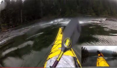
Thank you Mike Mattinson for sending in this neat video from your trip:  https://www.youtube.com/watch?v=82XdxO6QCvE

Posted in general interest | Tagged | Comments Off on Video: Running the Chute at Bowron Lakes

SKABC and the new Marine Trail in Howe Sound

As representatives to the BC Marine Trails initiative, interested SKABC members are continuing to survey information, land, and sea to retain and establish accesses, day use sites and campsites in and around the whole of Howe Sound as well as all coastlines of BC. Within the last few years,  the well- funded and widely supported  Canada Trails became  interested in establishing a marine trail from Squamish to Horseshoe Bay to divert around  a more difficult land route between these two nodes.  As this enterprise was an obvious direct parallel to the BC Marine Trails purpose, we were enthusiastic to support and ride on the coat-tails of whatever could be achieved in the relatively short time frame that was proposed.

To this end, several years ago SKABC marine trail reps Nick Heath and Mick Allen took  project manager Gordon McKeever on a motorboat tour to show locations that we had both been identified  and visited around the inner portion of Howe Sound. From this and subsequent work by ourselves (initial work and interaction), Canada Trails reps, and Recreation Sites and Trails BC,  a new Canada Trails ‘Sea To Sky’ marine trail is imminent. The new sites proposed will also be BC Marine Trail sites.  Moreover, this marine trail will also be  a small part of a larger complete Howe Sound Marine Trail which of course is a small part of the massive BC Marine Trails initiative - that the SKABC has been  enthusiastically supporting and its members  engaged in for years.GambierE-Ramillies-land

As a back ground to this, (you probably all have felt this as well to some degree while out there) but it is just so much fun and adventure poring over maps, google earth, trip reports, guide books and then on the water searching to try to find partially suitable, suitable, spectacular or even marginal locations. . . . and this was especially so in Howe Sound where one would think that because of development and proximity to the lower mainland that ‘new’ locations would be highly unlikely to be found let alone be quickly established as marine trail Recreation Sites (by RSTBC)!

PreliminaryMapPlanning

Click this map for a larger view. Finally, here are more details about the proposal:  The Sea to Sky Trail (PDF). Thank you Mick Allen for passing this info along!

Posted in conservation, trip planning | Tagged , | Comments Off on SKABC and the new Marine Trail in Howe Sound

Thormanby Trip Report Link Sept 5-7, 2014

Joan Boxall: SKABC member, blogger, poet, and travel writer, had some fun on
a (horse)-racy Thormanby Islands trip.
Read all about it on her blog,
http://www.joanboxall.com/horsing-around-thormanby-island-british-columbia/


Posted in trip/training report | Comments Off on Thormanby Trip Report Link Sept 5-7, 2014

Deer Group Trip Report – June 22-28, 2014

The trip started off very badly for me. I had just bought a new Greenland paddle, a high-tech blade made out of armalide. Armalide is a semi-mythical material, like mithril, supposedly indestructible by anything short of dragon fire. It worked very well for kayaking across the channel from Bamfield to Diana Island in the Deer Group, but once at the campsite I tried a simple Greenland roll and the paddle split in half while I was underwater. This was extraordinarily disconcerting, like the feeling Saruman must have had when his wizard's staff was shattered in "The Treason of Isengard". Fortunately I had a back up.

The day before, we had driven from Port Alberni to Bamfield, eighty kilometers of logging road enlivened at its mid-point by a poem, written in marker pen on a cardboard poster nailed to a pinetree, celebrating the solstice. Bamfield’s 200 inhabitants spend the winter months creating whimsical decorations for its boardwalk, including a grove of painted wooden mushrooms.

After the hot drive down the logging road, we assembled in the motel’s restaurant in search of cold beer. Our spirits rose at the sight of a row of beer pull handles at the bar, and were then dashed by the news that, although a wide variety of local craft beers would be available in a few months, the only thing available at the moment was a large ice chest of characterless American lagers.

Apart from the incident with the armalide paddle, the trip from Bamfield to Diana Island on the first day was uneventful. It was sunny, with a light wind and about a foot of swell. We pitched camp on the North shore of the island. It occurred to me that the campsite had a number of natural advantages, such as a rock-free passage to the beach, and the shining whiteness of the beach itself. Later on other members of the group explained to me that neither of these features was natural – the First Nations inhabitants of the site had cleared the rocks, and the whiteness of the beach was the result of millennia of their eating shellfish and discarding the shells.

There was heavy rain on the first night. Fortunately we had a large, professionally-tarped kitchen area. The following morning it was clear and clam, so we set off towards Folger Island, a small rocky island west of Edward King Island. The wind gradually increased as we approached Folger, the swell building up to four or five feet, so we abandoned our original plan of circumnavigating it and instead retreated to the west side of Edward King for lunch. From here, we passed between Diana and Edward King to the east side of the latter, and followed its coast down past an impressive series of sea caves, including a three-way sea arch.

While we were on this coast we could hear a deep, melancholy howl. At first we thought this was a foghorn, but later realized that it was a wave-actuated buoy in the Trevor Channel.

The party then split up, some of us returning to the campsite, a second group continuing to the southwest tip of Edward King and bagging the rocky islet at the end.

As we returned to the campsite, we could see fog forming between us and the Broken Group. Later, as we were preparing for supper, a deer walked down the beach and briefly stood on its hind legs to eat the leaves of an overhanging tree.

Wednesday morning started off foggy, so we didn’t get onto the water till 10:00 am. This time we headed north-east, up the coast of Fleming Island. A two-foot swell was rolling gently up Imperial Eagle Channel, surging through a series of rock passages and sea caves. The last and most impressive sea arch was at the western entrance to Robber’s Passage, at the north-east end of Fleming. Members of the party successively rode the swell through the arch, some of these rides being noticeably more exciting than others.

Robber’s Passage was strikingly populous in comparison with the more south-westerly islands, with a white-framed yacht club and a collection of yachts. A fresh wind was blowing from the far side of the passage, and when we crossed through into Trevor Channel, we met a two-foot chop.

The group again split, three kayakers setting a direct course for the campsite, the remainder of the group following the south-east coast of Fleming. As one of the three direct-route kayakers, I was very surprised to find the coast-following kayakers arriving at the campsite just fifteen minutes behind me. The three of us on the direct route had been paddling briskly, following a constant bearing, whereas the coast-followers had, we supposed, been frolicking in rock gardens and poking into the crannies of the coastline, so we had not expected them to come into sight for another hour or more. We eventually concluded that our route, though direct, had also been head-on into the waves and the wind, both of which the coast-following party had avoided.

On Thursday morning some of the group made an early start and paddled back to Folger Island. Again, as we approached it the swell grew higher. As we began to circumnavigate the island, we found the entrance to a sea cave on the northern side. It went very deep into the rock, and the roof came down almost to the water, but at intervals it was just possible to glimpse a bright light at the far end.

Going in search of the far end of the cave, we came to a beach covered with rocks. From somewhere behind these rocks came a low gurgling sound and an occasional squirt of spray. There was no way of approaching this by kayak, but exploration on foot led to a doorway in the rock, with water spilling over the doorstep. Looking through the doorway, it was again possible to glimpse flashes of light, periodically cut off by the waves. Anyone wishing to traverse this cave would have to portage their kayak up to the doorway, then swim it through the passage until the roof was high enough to board – technically possible, but perhaps not worth the effort.

We now paddled on to the west side of Folger, where the swell bounced back from cliffs to create an area of choppy, confused waves, or clapotis. A bald eagle perched on top of the cliffs and watched us. The water grew noticeably calmer as we moved away from the island and crossed over to Edward King, then up its eastern shore.

Thursday night was wet and windy, but the rain had stopped by Friday morning, and the sea in front of the campsite was calm. We again split into two groups, the smaller group making an early start and heading back towards Edward King Island. The wind was noticeably higher than the previous day, and by the time we reached the distal end of Edward King, we were in a four-foot swell with noticeable wind waves on top. A fishing boat a little further out was tossing about in a lively fashion. We went partway out towards it, then retreated to the more sheltered coast of the island, where we found a baby seal swimming close by its mother.

On several occasions this day, we remarked on the great contrast between the calm water in sheltered areas and the rough seas to be found where the wind blew, just a few hundred meters away.

After getting back to camp, at least one member of the party saw something that was almost definitely a whale, quite likely a humpback, about two hundred meters away.

Saturday morning we struck camp with remarkable efficiency, and were on the water, as planned, by 9 am.

Thanks to Karin for organizing!


Posted in trip/training report | Comments Off on Deer Group Trip Report – June 22-28, 2014